Thu, Feb 26, 2015 Afternoon Weather Notes
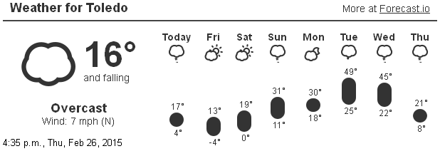
5:28 p.m. - February will end cold and in Toledo's record book. We may receive 3 to 5 inches of snowfall on Sun, Mar 1. Then we may see temps near 50 degrees with a thunderstorm on Tue or Wed. That will be followed by bitter cold temps on Thu.
Things are getting bouncy as Summer tries to battle Winter in what we call Spring. March 1st marks the first day of Spring on the meteorological calendar.
WTOL Meteorologist Ryan Wichman posted this tweet on Tue, Feb 24, 2015:
Following the cold yesterday, this is now the 3rd coldest month in Toledo history. Outside shot to crack the top 2:

March may begin with a few inches of snowfall on Sunday. Then temps will moderate by mid week.
Excerpts from the 4:15 p.m., Thu, Feb 26, 2015 Hazardous Weather Outlook:
temperatures will be very cold again on friday night with lows ranging from 5 below to 20 below.
a low pressure system will move across ohio on sunday bringing accumulating snow to the area.
several inches of snow are expected and an advisory may be needed. stay tuned to later forecasts for updates.
At the moment, we're in the 3- to 4-inch snowfall range. The heavier amounts are currently forecast to occur south of us.
Excerpts from the 4:12 p.m., Thu, Feb 26, 2015 Area Forecast Discussion:
forecast does not include snow that far out but looking like a widespread 4-7 inches. this looks most like an advisory event but can not rule out higher accumulations or warnings at this time.
The next mess may occur on Tue and Wed. We may receive a fair amount of rain and possibly a thundershower. Then temps plummet on Thursday.
More excerpts from this afternoon's Area Forecast Discussion about next week's weather:
temps could be already on the way down by daybreak wednesday... or it could be 50 degrees.
other possibilities will have to [be] examined as confidence increases and we get more comfortable with the timing such as the risk of flooding and the threat of thunderstorms.
unfortunately... all signs point to a return to much colder weather again after the cold front goes through on wednesday.
a trailing short wave could bring lingering snow showers into thursday.
NWS Forecast:
Friday Night: Mostly clear. Cold with lows around 7 below. Southwest winds 5 to 10 mph. Wind chill values as low as 14 below.
The record low temp at TOL for Feb 28 is -7 set last year.
NWS Forecast for mid next week:
Tuesday: Snow and rain likely. Highs in the mid 30s. Chance of precipitation 70 percent.
Wednesday: Partly sunny with a 30 percent chance of snow. Highs in the mid 30s.
This forecast data predicts significantly warmer temps for next Tue and Wed.